The British Isles
 Colaboración de la maestra de Inglés.
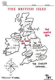
Ficha para iniciar a los niños en el conocimiento de los distintos lugares donde se habla la lengua que están aprendiendo. En este caso en particular, hablamos de la Islas Británicas, capitales, lenguas y nacionalidades.
Los niños completarán el mapa con ayuda del profesor delimitando las zonas con colores según las siguientes orientaciónes (descargables en pdf al final del artículo):
The British Isles are all the islands surrounding and including THE UNITED KINGDOM ( UK ) and THE REPUBLIC OF IRELAND.
THE UNITED KINGDOM (UK) is divided into GREAT BRITAIN and NORTHERN IRELAND.
GREAT BRITAIN is the largest in the British Isles and it consists of SCOTLAND, WALES and ENGLAND. The capital of Scotland is Edinburgh. The nationality is Scottish. They are called Scots too. They speak English and Gaelic. The capital of Wales is Cardiff. People are called Welsh. The speak English. The capital of England is London. London is also the capital of Great Britain. People are called English and they speak English.
NORTHERN IRELAND is the part of Ireland called Ulster. The capital os Northern Ireland is Belfast. People are called Irish and they speak English and Gaelic.
On the other hand, the capital of the Republic of Ireland is Dublin. People are called Irish and they speak English and Gaelic.
STRUCTURES
- Where is…?
- What´s the capital of…?
- Look at where Scotland is.
- Point to London, Exeter……
- People in …………… are called …
- What is their nationality?
- What language do they speak?
DESCARGAS:
Para descargar la ficha del mapa haz clic sobre la imagen.


Deja una respuesta